Does the word that just popped into your head show up here? Find out:

Showing posts with label islands. Show all posts

02 November, 2013

Feeding the Hand that Bites You

"So long, and thanks for all the fish."
The last book I read was about the Nez Perce war, and right now I'm working on one about the Puget Sound wars, treaties, and trial of Leschi a generation earlier. It ain't pretty, and ties into why I'd rather fill out "Other" than "White" or "Caucasian" on forms that ask for ethinicity. I have to assume that a large percentage of "Others" are similarly aware of "white" misdoings (I'll leave the "Caucasian" misdoings to that Caucasus favorite son, Joe Stalin).

Another Joseph, the Younger Joseph of the Nimipu (Nez Perce) was betrayed and hunted like a disagrreable neighbor's rabid dog a generation after Leschi of the Squally Absch (Nisqually) was killed like,...the same. The reason for this was not that either of these men, their forebears, or their kin, had done wrong by American settlers. To the contrary, Nimipu and others saved Lewis and Clark from starvation, provided guides, and even horse-sitting services, without which the Corps of Discovery would not have reached the Pacific, much less returned home. Leschi and others accomodated Hudsons Bay men and even attempted to deal with the Bostons (Americans) and their psychopath Governor of Washington Territory. 

As in Jamestown and a thousand points of dark in between, tribes in the Columbia Plateau and Puget Trough first dealt with west-hungry explorers and settlers by feeding them. Thanks for the Giving.

But food for the small settlements only led to hunger for everything outside the pale. Lewis and Clark handed out medals, but later American settlers grabbed and acted offended when the natives wanted to stay free on the land they'd tended for millennia. Even in the middle of the Pacific Moana, sons of missionaries who had depended on the kindness of kanakas turned around and plantationized islands, pauperizing most of the inhabitants.

Fresh out of native people to rob, the American elite eventually turned to stealing Africans and distilling wealth from their sweat (yeah, the Yankees did it too, with shiploads of human cargo headed to the plantations). Once they ran out of brown peoples, the uber-white people turned their attention to their unter-brethren, continuing to concentrate wealth among the few while consigning the masses of crackers to poverty. The process continues unabated (accelerated, even) until today.

But none of this would have happened had not Wahunsenakawh (Powhatan) fed the hand that would eventually bite him and eventually everyone else in Indian Country. As my people say, "No good deed goes unpunished."

24 November, 2012

Two Ferries


Apropos of nothing, i drag forth from the archive a couple of photos from ferry rides. One of a San Juan run so sunny and clear that I felt like I was on the boat to heaven. Another on a greyer, more ambiguous day when the destination was shrouded until we were nearly there. These were both fun rides, one not really better than the other, each merely a means of transport to the observer, but each also an adventure and miraculous journey in my mind. The ferries of Washington, white and green, filled with cars, thrummed forward and back by diesels, seem so same, but each route is unique, each passage a new experience. Commuters may dull to the beauty, but I love each ride.

01 September, 2011

HI NW

Maybe you knew about it all along, but it was not until I was fully grown that I learned about the Hawai'i - Northwest connection. Cook and then Vancouver sailed (and ailed and aled) between these places in the late 18th Century, and there are those who feel that certain petroglyphs in Bella Coola may demonstrate that the Hawaiians had already done so before. The Hawaiian islands provided sandalwood and firewood, provisions and crew (weary and horny Anglos jumped ship in Lahaina, and adventurous Hawaiians took their places) during the fur and silk trade. Maybe because they both loved kings, the Hawaiians and British took to each other, among the expressions of which was a minor migration of Hawaiians to the Columbia and points north, in country that was then more Brittanic (or Gallic, maybe Russki).


I moved to Hawai'i before I knew any of this, and so I was a little surprised to find that a favorite dish there, and pretty much the only local kine grind with land-based non-starchy vegetables in it was something called lomi salmon. Tomato (hard to grow in the islands since diseases and fungi caught up, but historic sources indicate it did alright soon after introduction), onion, and salt salmon. It looks like this (but tastes even better):


"Lomi" derives from lomilomi, the Hawaiian art of massage. You need to turn the ingredients together with your hands to get the  tomato juice on the salmon, to bleed onion spice into the tomato, and to spread the salmon salt throughout. 


I made this last week with the trimmings from a king salmon I'd inexpertly filleted. Salted and drained and resalted and redrained and salted again the bits o salmon. Rinsed and dried and added a diced Yakima tomato and homegrown progeny of Walla Walla onion. 


None of the girls would share it with me, because they figured the salmon was raw. True, it was never cooked, but the salt basically dehydrates it, so it does not seem so raw. Not exactly jerky tough, but the salmon ends up being a salty, slightly chewy nugget in the soft tomato matrix. The onions add crunch, sweet allium crunch. I had no ogo, but may try to get some next time. 


This dish marries the Northwest and Hawai'i Nei, transcending a swath of the world's largest ocean. To eat it is to consume history, to break open the barrel of salt fish in a Honolulu house, to hybridize cuisines in a Kanaka Village kitchen on the Columbia. To have it here and now, with a sun-ripened tomato, a sweet onion from my yard, and a salmon that swam the morning before it was salted, is delicious beyond description.

29 August, 2011

Fear and Loathing (and bliss?!) in the San Juans.


Last week, I traveled to one of the San Juan Islands. Sounds like a place in Latino Latitudes, but they are our northernmost islands, ever since I stopped counting Alaska. After S. Palin said she could see Russia from there, oligarchniks have quietly been buying back pieces of it, and they now own enough land, oil futures, and moorages to have reversed Seward's Folly.

Meanwhile, down south, I sat on the deck of a small workboat, skimming o'er glassy waters on the way to my favorite island this side of Kaua'i. It was an international expedition, more or less, there being employees of two sovereign nations aboard, but tensions were low. My coffee buzz, borne of a 4AM wake-up and 2 or 3 hours of not-quite-as-fast-as-that-douchebag-in-the-BMW driving, was gone by then, and the remainder were northwesterners, cool enough not to let their 30% caffeine bloodstream affect their behavior. 


My job was to make sure a little hilltop was an OK place--archaeologically speaking--to plant a small weather station. I knew this would only take a few minutes, but was interested in what the reps of this other nation had to say about the whereabouts of a place that all of us agree exists, but none of us has been able to locate on a map, much less on the ground. Or, too many people have been able to locate it on a map, but they don't agree. Not violently, or even vehemently, more in the manner of a loss collective.

So there was no drama. No conflict. No more to write about.

So I ambled over to a place where some workers had been, uh, working. With big machines. And they'd gone where they were not supposed to. And obliterated some stuff. 

Irrevocably. Done. Nothing more to say.

So I continued to the south beach. Solo, toward the solace of data collection. The home of a man who invented a particular kind of mill saw, reduced for the time being to notes and numbers. Measured, sketched, GPS'd, until there are hours to rediscover the stories and graft them back to this bare limbwork. Sounds dull as it gets, but the uncreative busy work soothed me just then.


Moving on, it was time to climb. 600 or so feet up is the summit of a hill called Olivine, and for part of the way I followed old miners' roads, weaving twixt boulders loosed from earth but not barged away. Higher still, heading for a bald patch where I might have left a bag carrying camera and binocs, lost on the last trip here. In the camera, a memory card holding the only images of that place that had been torn away by machines. In the binocular lenses and dark interior, lagging photons showing 21 years of birds and cliffs, of places unreachable and just plain look-worthy. Memory and data, at waypoint 680. Maybe.


But only after crumbly cliffs and a final steep ascent under a sun as glaring as it gets in these northern islands (Not saying that much, Hawaiians, but acclimated me felt hot.) And there, in the place I had sat: nothing. No camera, no binoculars. Oh well. A pretty day, views down to the island (and a camera to catch 'em), the channels, more islands and straits, ocean. Boats unzipping wakes. A bell clanging in its language, inscrutably charming to my ignorant ears.


It was all downhill from there, beginning easily enough with a trail. Becoming a trace. Then just places less tangled than others. Then ever more precipitous slope, alternating between slick bedrock and loose talus made one by a moss skin over a skeleton of roots and rot. One leg carefully lowering my entire weight, then the other. Zig-zag switch-back, starting to wonder if I'd be back to the dock on time at this gastropodean pace.


On the other hand, it gave me time to appreciate the ancient fire-scarred trees scattered in this slanted forest. Occasional grandfathers, gnarled and interesting, surrounded by young'uns. 


I was looking up at one, it's branches akimbo with codgerhood and a disregard for verticality not tolerated in the tree farms and young forests I usually travel. Hunter S. had gotten that way in his old age, and years earlier had been nearly as curmudgeonly in his dismissal of amateurs one toke over the line, scoffing that until they'd dealt with the acid bats descending near Barstow, they had nothing to whine about.


And maybe getting all worked up over a hallucination is not that big a deal either. Imaginary bats swooping from the sky may be bad, but real yellow-jackets swarming up from their nest in the depths of hell ain't no picnic either. I'd been strung three times  before my body responded. They never really entered my vision, barely nicked my consciousness as anything other than pain when I took off in a clumsy cetacean approximation of running. Another sting, and realization that I'd be stung to death and devoured by the yellow-jackets at this rate.


I either stumbled or decided to jump, who knows? In any case, I looked down-slope and saw my feet before me, plowing downhill as I slid my butt across moss and logs, bouncing off rocks, pawing and clutching at whatever could help me steer this descent, maybe keep it from accelerating out of control (any more than it was). Extreme luge...sleds and ice are for panty-wastes. My mind thinking only of getting away from bees. Eyes pitching in by trying to spot a precipice before it was too late, and managing to do so.


Stop. Stand. Stung.


Again with the mad down-ward dash. Hop and lope, slide and hope. Managing to stick most of the landings and surf over a salal patch without it clutching me. Finally finding myself having covered a lot of ground, much closer to my destination. More importantly, out of the airspace of the squadron scrambled to chase me away. Not long after, I walked onto another old road, ambling calmly dockward. About 5 stings big enough to qualify, but no gashes, serious bruises, or broken bones sticking out of my skin. 


All in all, not a bad day.

11 July, 2011

Pleading the 5th

The flag says the wind is waking on this 5th of July. The sole sign of the 4th is an over-stuffed trash can, visited now by a raccoon who nearly tricked me into missing sunrise, but this is all aftermath. I'll get back to it eventually.

A glow through the curtain crack told me it was after 4AM, when the sky near the Canadian border wakes and stretches, scratches at the dark, itching to become dawn. My family sleeps; I slip onto the balcony to see the shift. This is my church.

Above, the celestial blue is deep, but shallower than bottom, already less than the darkest our short Summer night offers. The horizon rolls out red as I stare out toward sea level, maybe 20 feet below my vantage and stretching for miles across the Strait.

Straight lines, but none of them able to withstand close examination. First and most obviously fallen: the horizon. A seismographic line of dark beneath the red, mountains pushed up by countless quakes, volcanic peaks like Baker and Glacier stand in for the big events, while mumbling multitudes remind me of the lesser but commoner rumblings that keep the Cascades rising.

Just above, lines between blood red and bled red, between the warm hues and blues. Infinitely many and fine lines. All straight in my pitiful little human view, but arched across the planet's fulsome curvature. And just where are the lines between redder, red, blue and bluer? I cannot pin them down, each dissolves color into colour, moving as unchecked as the rotation of our sphere through aeons, never to be delineated.

The water's surface, could I see it off in the dark distance at the foot of the rising Cascades, would be as straight as it gets. Pre-dawn calm, glassy smooth, perfect reflectory for the light show and the jagged silhouette of the mountains. But curving around the globe, warped by tides, and at any close view too cleaved and waked, blown splashed eddied and flaked to be truly straight for even a few feet. Water flows and will not be imprisoned by plane geometry, though for a crystalline moment it may let you squint and imagine mirrorine perfection, time unmoving.

Over the next hour, the calm is invaded as the approaching sun awakes winds. First, rifflets--islands forming. Then an archipelago. No white-top chop, not yet waves, really, no undulating horizon, but still the glass has shattered, letting me know that the flatlining peace of the un-dawned day is about to pulse to life and light. Before too long the meditative reflections have been swept away: the schooner's mast rippled apart, the seismograph of hills even more spastic, the stars and planets lost again.

Still, there are islands of calm. Lees maybe, or less romantically, sheens of oil or whatever was in last night's fireworks. But the way the wind blows and the tide flows, and these islands of calm remain, I suspect they are the deep waters running still. In and around one, a seal's head and wake sketch dances on the surface, then disappear. A pause, and then another dance. Neverlasting, never over. A fishing hole, maybe, some mystery known only from the underside.

Closer, in the thin strip by the strand, a raccoon mama emerges from the rip-rap and scrub-brush to investigate a trash can filled beyond capacity by last night's revelers. My eyes obey evolution and look. The tableau beyond, no matter how sublime, cannot compete with the creature. Like a fly crawling across a master's canvas, it demands attention, at least momentarily making the human eye follow motion and forget art.

But not for long. I've seen a grander motion already, and resolve to focus on it. From peaks left of the big mountain, shadow rays have shot subtly through the glow. Fanning darker into the lightening sky, lines of blue hue washing the warmer colors, paradoxical announcement of light soon to come. My eye rides them down to their center.

And in a bowl twixt peaks comes a brilliant green flash. More than a flash, a growing bubble, bursting finally into the yellow curve of the rising sun.

And day dawns.

Quickly the red draws itself on a line west, beyond my view. Maybe at my zenith, still there for the watchers beyond Tatoosh, but soon enough passing them as well, racing across the Pacific, chasing away stars and dragging up winds in its wake.

The sun stabs straight at me, as it always will over water. This low, the glaring orb remains attached to the long ellipse of the blade, and for the first time I see the sun's first reflection as a paddle, the sun a knob on the handle, slender Salish style, dipping into the sea. And so starts another journey.

09 June, 2011

Why Did I do that?

The last post had to do with reading, maybe re-reading 1984. Which was a mistake. Incredibly depressing. When the message is that the future is a boot stomping on a human face, forever, then it's time to stop reading. Ignorance may not be strength, but the bliss will do.

Then, I spent time on an island. That always seems to help. Beautiful country, interesting fieldwork, and peace. Lambs and sunsets, seals and kelp. More on that later. For now, back to the techless happiness. 

In what may turn into an ironic twist, discovery of a nice used book store on the island, turned into purchase of a book on the history leading up to the Everett Massacre, a dark hour for the proles and outer party dissidents.

30 May, 2011

Old 'Awa, New Tea


The great thing about a 3-day weekend is how it gives you time to concoct a complex plan, get started, procrastinate, rush to take care of the chores you'd ignored before because the project seemed cooler, and finally make a little more headway on the project before collapsing in lumbar agony. That's why I am sitting on a heating pad with stacks of wood cut, yet unjoined, in the garage.

My ridiculous primate architecture is modern enough that the skeleton is no longer so adept at canopy cavorting, but in many aspects not much different than a Cambrian creature. The spine is fine supine in the ocean brine, but sucks for feet on concrete or bending over.
In Hawai`i, one option was to drink some `awa (a.k.a. kava in most of Polynesia, yangona in Fiji, or Piper methysticum in the priestly language of botanists), which relaxes the muscles and either alleviates pain or makes a guy forget it in the midst of kava conversation, which flows easily and abundantly. I've seen it called a narcotic time and again, but it just ain't so. I used to sit under the banyan tree at the community garden, having a few cups with the Rotumans, Fijians, and Tongans, spinning yarns and stringing stories. Tongue numbed and eventually legs too, but nothing like being drunk and much subtler than the western pharmacornucopia had trained me to withstand.

I grew a dozen or so plants in the cinder  of Puowaina, adding years of leaves and compost before anything was harvested from black soil full of worms. Most were still going when I moved away from the islands, leaving them in good hands. The ones I dug were approved of by the garden crew, and my finest waka roots made it to Kona, to Nu`alolo, to Moloka`i Nui a Hina. 

Anything left from that batch would be a decade or more old at this point, but it turns out that I had some other `awa in the freezer, sitting untouched for who knows how long. I know a guy who spent a little time in Fiji and a few people with Hawai`i connections, but nobody to sit with and socialize over a bowl of vintage root. So, I broke into it for the medicinal value tonight, and here I sit, obviously feeling well enough to remain in the chair and blather on. So now I know that yeah, kavalactones retain some effect even after years in a freezer. Enough so I can blather further on. And on.

And off. To way back when I was writing about blackberries, a couple of posts ago. That had to do with another type of drink: blackberry leaf tea. Specifically the local native known as the trailing blackberry (a.k.a. dewberry to people who are more mature than I am, or Rubus ursinus to the science Latinists). I had hoped to dry it under the sun yesterday, but the sun got wind of that, and hid behind the clouds, snickering audibly. 

I'd also planned to cook up some tender shoots, but got waylaid by designing and starting to build something, and instead put off even stripping the leaves off the stalks til the after dinner sun-break today. The result is shown below, inside and away from dew, sending out aroma runners through the house, tendrils of citrus and banana peel wafting and tickling noses. I think it'll be good tea. 


27 May, 2011

Backroads: The Kelp Highway

On the Kelp Way in Clallam County, looking over at Vancouver Island.
How about instead of a backroad, I follow the first road this time? The stream so main that it was traveled by the first people to head east into the Western Hemisphere. For most of my life, this was presumed to have been the Bering Land Bridge, the rim of Beringia, a tectonic plate where some dry land peeked up when glaciers borrowed the ocean's topmost fathoms. People followed game across the arc of dry land, and ended up in the New World, where they made big fluted spearpoints for the convenience of archaeologists, who would name them after the town of Clovis, named after the first King of the Franks, who never conquered anything within a few kilomiles of New Mexico. What these people called themselves, nobody knows, but it was probably the same as nearly every other culture that has had the sense to avoid citification: "People."


It does not much matter, since Clovis people came along after others. Earlier sites have emerged over the years, and though plenty of people argue against the 40,000 year old dates in Monte Verde, hardly anybody disputes that 15,000 or so (feel free to give or take on the order of a millenium or two) is OK. In the old days, this was a problem because the period when the land Beridge was exposed was later. But now we know that people lived here before they could walk here. It already looks ridiculous and bigoted to espouse such an utterly baseless theory as "People could not get here except on foot. The land route was not available until 11,000 years ago. Ergo the hemisphere was settled after 11,000 years ago. Oh, and aren't these spearpoints cool?"


Sure, Clovis points are cool, but you know what's cooler? This:


This is an older type of point that has been found along the Pacific Coast. In the California islands, it was found along with a lot of bird bones, and is presumed to have been used for hunting them. The most common name for these is "crescent points," because they have that shape, sorta. What they look even more like is half of the bottom of a cowry shell, but the point is that they are every bit as beautiful as a Clovis point, and from a functional standpoint may be even more elegant (there are a bunch of Clovis points that would be useless for hunting, they are so big). 


The photo comes from an article here: Link

I don't know a lot more about this than you (maybe less), but the idea in that article and elsewhere, that the people who made these artifacts settled the New World by boat, is hard to resist. Kelp grows continuously enough along the shores of the North Pacific that long open-water voyages are not necessary (also: not precluded) to get all the way to California. Kelp forests are incredibly rich in food, and their wave-dampening fronds offer canoe people the respite of smoother water. They offer access to shellfish clinging to rocks that would be extremely difficult and risky to get at on foot. They take People alongshore until they find a nice place to stop for a while. Or even stop forever, set up a village and stay. Even those People, however reluctant they may be to set out on a thousand mile trip, venture back into kelpy waters regularly for everything from the kelp itself to fish, birds, molluscs, pinnipeds, crustaceans, and all the other orders of life stacked in the deep larder of a kelp forest. 

Kelp Highway Off-Ramp.
Glaciers plan to return still more of the water they borrowed during the Pleistocene, and we can look forward to more drowned land. By the time we run out of petrochemicals, we may have difficulty walking between hills that have become islands. Kelp and kin will still be there, topography will become bathymetry, and the seaweeds will cling to it. Even if (OK, when) the big one hits, the Subduction Zone quake that drops pieces of crust deep below sea level, then kelp thallus will respond with prodigious growth; the kelp forest will just get taller, more fecund. If we adapt to reality, and don't insist on living by some back-asswards theory, we'll be alright too.


11 April, 2011

Once and Future Islands


Early March found me in the Skagit lowlands, field after field of flat. Not much growing now, just puddles of rain and snowmelt. And maybe the water table coming up. Meanwhile, on NPR, the US Navy's chief meteorologist was being interviewed. The military is not exactly a bastion of liberalness (the policy for left of center personnel is Don't Ask, Don't Tell, with no end in sight), but when it gets down to brass tacks (or shell casings) they don't have a lot of patience for cockamamie right wing theories that fly in the face of science. A lot of math was developed with trajectories in mind; physics, chemistry, and materials science are at the heart of many a weapons system. Communications, surveillance, keeping copters and jets in the air,..the list of military needs that won't work on the basis of Creationism or Faith goes on and on.


This extends to long term planning, which is where the admiral came in. A scary proportion of Republican congressmen may deny the existence of global warming, but the US Navy sure as hell doesn't. They know that the sea is rising, and that the rate could suddenly increase if and when the Greenland ice reaches a tipping point and starts flowing into the sea at more than the accustomed glacial speed. They know that this will bring them headaches ranging from submerged and storm-battered bases to increased geopolitical stress and strife as populations migrate inland and fresh water tables are salinated. I'm sure the admiral would love to believe that it won't happen, but he knows better.


The low fields of western Skagit county have tasted the ocean before, and will again. The hills that poke up through the coastal sediments, long seen by farmers as intrusions into an otherwise nice field, will once more become islands. The dikes that have held back the Salish Sea will be gobbled by it, deltas will erase levees and fan out. 


All this in a blink of a celestial eye, a tic of geological time. The far-flung flats are no older than the last glaciation, anyway. The waters of the straits and sounds, seemingly so protected from the ocean and buffered by islands, rise and fall with wild abandon in just the short time that humans have been here. Not entirely because of water being frozen and then released, either. The land itself rises and falls as glacial weights pile on and flow away, as the oceanic plate plows beneath the continent, as faults give way. Some of the San Juan islands bob up rather gently on the rebound after glaciers leave, while others were thrust up suddenly from deep in the earth during subduction zone quakes that dwarf anything humans can recall. 


The Japanese quake and tsunami remind us that cities can be erased suddenly, landscapes altered in a day. (The geologists' office where I work displays a quote from Will Durant, "Civilization exists by geologic consent, revocable without notice.") The climate's change promises us a less obvious, but far more widespread, alteration of our earth. We humans, clinging to the coast, are in for some hard lessons, especially if we insist on denying what is demonstrably true because it does not comport with short term political goals or a particular religious outlook. Reality won't wait for the slow-witted, and even if they manage to make an ark, their drifting voyage will find whatever shores it may reach already occupied by people who operated not on faith, but on knowledge.

05 March, 2011

Combover

I saw this the other day, an artifact for the future, but from my own past, so too modern for my taste.

I was on the Island again, gales having blown away my chaces of getting there last week when I could have seen some snow. This trip was with one of the tribe's biologists and archaeologist, and we made a circuit of the meadow, which is saturated now, and talked about what kinds of things might be done to restore the natural ecology. ("Stand back and wait," I want to say, but people want to see something happen in their lifetime, preferably before they are old, maybe this biennium before funding is diverted to cover a war or corporate welfare.)

One thing that tribes and scientists and land managers seem to agree on is that the dike cutting off the estuary ought to come out. Of course, the dike was first built in the 1870s, and therefore is a historic resource, something whose preservation should be considered.

But winter storms in the last two years have begun to erode the thing, revealing that most of the dike is not that old. I'd figured 1960s or 1970s, and on this trip, the latter and later of these seems right. I had a comb like the one in the photo. When I was small, they looked very similar, but the teeth were brittle, snapping off and allowing channels of snag to slip through. These must've been thrown away in droves, and will be abundant in the archaeological record. But the one show is "Unbreakable," rubberized or something. Boys carried them in their hip pockets into the 1980s maybe. I stopped paying in attention when I stopped combing my hair in '79 or so (a streak that continues!), but I am pretty sure these became uncool not long after.

The biologists were a little impressed by this deduction, and maybe in awe of my nerdiness and ability to ply my trade in such shallow waters.

One day, when the dike is removed, I'll be there, scampering around the backhoe, rooting in the backdirt. The comb, like the ruler I found last time comes from the recent history of the place, when there was a school for boys. The fill that was pushed here encapsulated some of their history, from a time when I was a boy too. Maybe I'll find evidence of the brittle-Unbreakable sequence, maybe some toys or school gear, maybe Piggy's broken glasses or a conch shell...

11 December, 2010

Human Tides

People come and people go from faces of the earth. Our kind are increasing here in the maritime northwest as on earth as a whole, sprawl marches along highways, farms are gulped and a hundred plots plotzed out. It seems inexorable (as if I even  know exactly what that means), this primate tide.

But if you go out beyound the sprawl, go into the dark wood and windy mountain and all manner of muddy places our modern feet fear to tread, there are the high water marks of earlier waves of first people and the 600 generations that followed. Nature west of the Cascades swallows whole towns in a generation or two. I've been in places that had a hotel and a bank, a post office, neighborhoods and cemeteries, a good-sized herd of humans at the dawn of the atomic era. But then when all the trees had been cut, it was over. Railways pulled for use elsewhere, materials scavenged, everything else made of wood rots, archaeology gets made. Blackberries and alder thickets make it hard top gain entry anymore, and in less than a human lifetime are succeeded by evergreens that eventually create a blanket of roots over the whole thing.


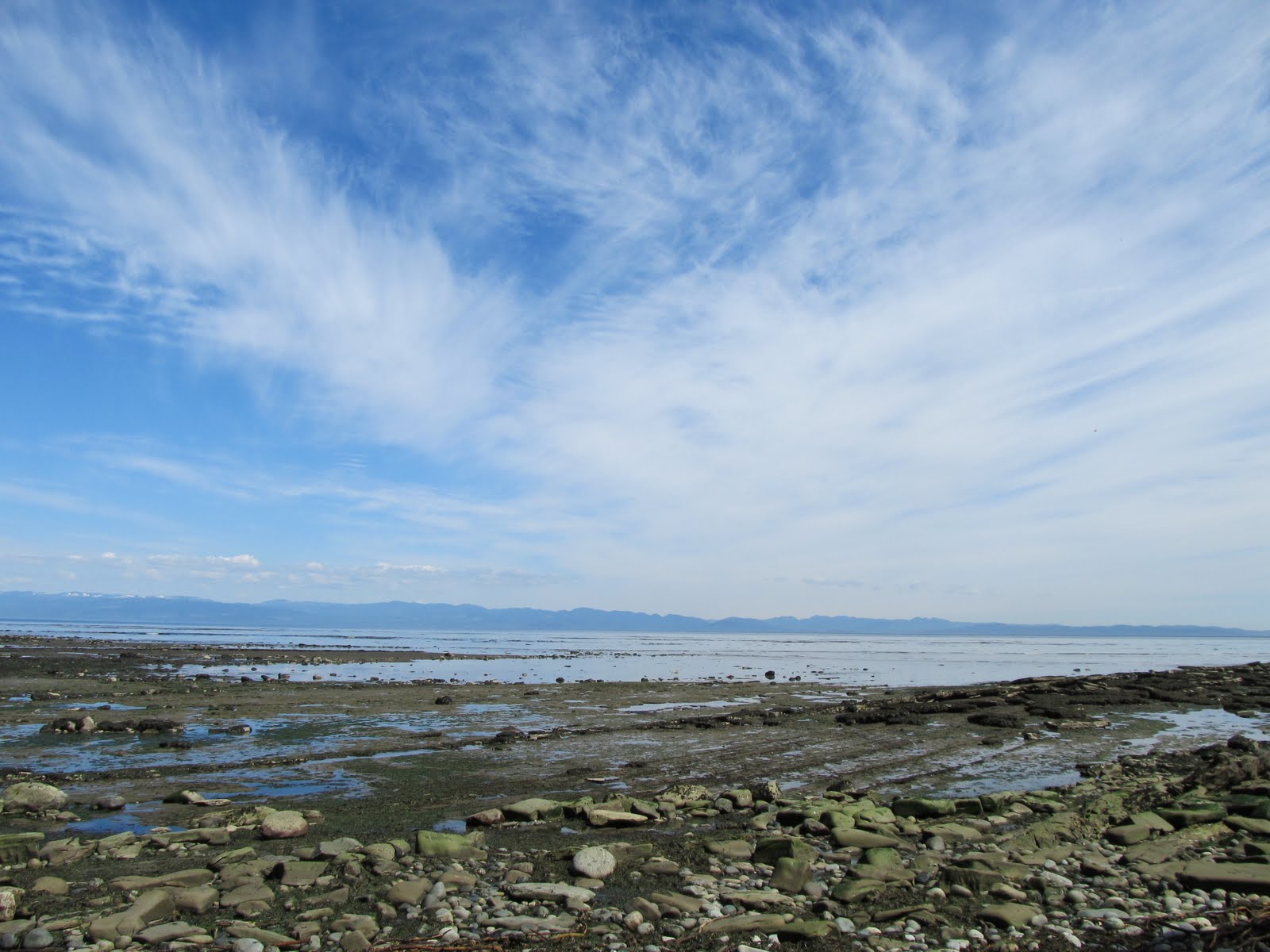
Humans have ebbed off lands we think are wild now, and our own dominion over earth is bound to falter eventually. The ebb is in effect at Secret Habor, where an entire school campus was demolished almost two years ago. That's the photo here. If you know what you are looking at, you can see slope cuts where the main buildings were, and the backhoe is in a basketball court about at the spot where I found an old pitcher's mound buried in the fill. I think only 3 structures remain, with another 3 cabins on nearby private land.

This human retreat happens to be intentional. The school wanted to move to the mainland for logistic and financial reasons, and the state wanted to manage the island as a natural area. One thing still to come is removal of a dike, which is also in the photo above--its the shoreline at the right. Again, the cognizant eye immediately notices that the seaward face of the dike is eroding. About a horizontal foot is gone since a year ago.

In the 1870s, the first white homesteader diked off part of the estuary and managed to do a little farming. He didn't last too long, though, and in the 1880s along came Shadrach Wooten, who had married into the local tribe and may just have been moving to his wife's family place. Same thing happened with Mr Hansen, and those two families represented the high water mark for a couple of generations. Did they maintain the dike, or let the sea flood back in? I don't know.  By the end of the Depression, none of them lived there anymore, anyway.

After WWII, a Seattleite decided that the harbor could be a haven, and over the last half of the century there was a school for boys. During this time, the dike was reinforced and raised; I found a ruler in the fill, a spray-paint can embedded in a concrete seawall.

There have been other ebbs and flows on Cypress. The capitalist alchemy of tranforming salmon, timber, minerals and even wild rhododendrons into cash came in boom-bust waves crested and fell quickly. A tourism wave was proposed, and although it never really materialized did manage to carve out a few marks on the landscape. Older peoples interested in maintaining populations of strawberries and deer, roots and fruits and wood...their waves oscillated more in time with the seasons, and were less inclined to scour the land bare on their way out.


Enough of the fluff and opinionizing. Let's get back to dirt. This is the profile of a trench, with the water table at something like 125 cm below surface. Down there, you have clay that gets sandier the higher you go, until hitting an organic layer. In some areas, this has a lot of bark, in others there is perfectly preserved grass, and in others it's a finer peat. Could be from logging, a different sea level, ancient human intervention,... Then there's another run of grey clay into sand, and then you get into modern fill.

As you can see, there's a wooden pile, driven into the lower grey, and either very short or cut off at the inception of the uppermost fill. Cypress timber was tough by virtue of low rainfall and serpentine soils, and prized for pilings; several turned up in this trench, and none were creosoted. They are neither ancient nor modern.

I'm really only starting to analyze the sediments, and at some point will have to find funds or a compelling con to get dates and expertise. I'll get back to you when I do. 

07 December, 2010

Cypress Again (Finally)


This third Summer in the NW began to seem familiar, my body more used to the rythms, seasoned enough to feel comfortable just past halfway north to the pole. And as you may recall, I was pretty sure I knew ahead of time that August would find me on Cypress Island.

But government time does not comply with the seasons, and even though they recognize years and do some things annually, they prefer the biennium. So August slipped to Sept., then boat trouble delayed the whole operation to October, maybe Halloween, but still I drifted along in the belief that in the islands, Autumn falls softlier than where I live, and the trip could still play out under that season's rippling sideways sunbeams.

But the calendar fell subject to arcane formulae concerning the availbility of funding, rules rules and more rules, other project timelines, and quite a few other variables of less or more dubious officiality. Government time set the trip for late November, when it would finally be darker and rainier than usual. Specifically, early on the Monday after Turkey Day, which meant a Sunday drive on I-5 with a million other people.

Foreboding didn't really have time to set in, and my hermitty self grinned at the promise of island seclusion. The road was crowded, but not clogged. Everything went well dockside, then a run no more complicated than dodging crabpots in Secret Harbor. The predicted gale held off til late in the day, by which time we were tucked away low in the lee, watching low clouds skudd, but feeling only the greatest gusts. (The return was on a channel glassier and calmer than I'd ever seen it.)

The boat and backhoe pilot stayed over, more fun than hermitage, and remained a few days til the work was done. It's really nice to work with someone you don't know, and find out that they're interesting and can handle themselves in the field.

My part was spending time in trenches through the old ball field, filled in past years and destined to be re-opened to the ocean in future biennia. So I was looking for things in the fill to tell me when they were deposited, and found a pitcher's mound and superball (no earlier than 1970s, based on materials).

To get deeper we had to run a pump, which at times would empty the trench quicker than water at the far end could drain. Other times it just choked on clay or the rodent who'd drowned the first night. In the 40 minutes or so between pump and seepage victories, I walked the muck, troweled clean the walls, drew stratigraphic profiles. Oh, and shoveled saturated muck.


Like all good dirt, this stuff says something. I haven't figured it all out yet, but the sequence of sand, clay, sand, organic, clay, sand, fill tells a tale of a Salish Sea and people. Was that organic layer a natural thing, maybe when glaciers sucked the sea shallower? Or a Salish woman's silverweed marsh garden? Or logging droppings?

Questions to ponder later.

21 July, 2010

Cypress Moon

Somewhere sometime back I said something about sticky places, specks on the globe that have the power to hook a guy, play out the line sometimes for years before reeling him back, maybe let him take off on another run, but always that little bit of drag, that tugged lip, pointing back like Elvis's lip did to Memphis.


Maybe I also blurted out something about how new places keep sticking to me: ancestral farms and grandma's and mother's houses, gardens of my own, settlements Virginian and Hawaiian, grounds in both Washingtons. Maybe I revealed that Cypress Island is one of them near my latest abode.


And already it is clear that this island is where I will end up in the August moon. In the past two years, events have conspired to send me there and then. Today I learned that it will happen in the third as well: a descendant of the islands only Zoe (so far as I know) needed to reconnect with her kin's story and organized a trip, a coworker who took over a restoration project wants to walk the place with an archaeologist, and then there's me--more aware than ever that an August trip to Cypress is a treat not to be refused. 


Treat? I mean blessing. And so the fishing metaphor ends (because that would be a sham, as you aware of my paltry angling acumen must already be thinking), with me swimming willingly back to this place, as I hope to to Nu`alolo in the coming year. Lured by the aroma of those sweet springs, beckoning tendrils cast into the deep blue, that vast and shapeless world, luring the shad, o'opu, and salmon. 


So, maybe a fishing metaphor after all, but more of the ancient and collective "the run delivers fish" kind than the "guy in a bass-boat with an armada of lures" kind. Either way, I'm hooked.


12 February, 2009

More Birds

Protection Island, in the Straight of San Juan de Fuca.
Septemb er 2008.


Geese coming around Diamond Point. Protection Island in background.


Gulls at the Protection Island Wildlife Refuge. Olympic Mountains in background.


Mmm. Guano.


Those cormorants again.


15 April, 2008

Island Truck Trek


After all the years in Hawai`i, the concept of driving from Island to Island was strange. (I lived there before the Superferry was foisted.) Puget sound's fjording tentacles are bridged, as are some of its island channels. This shot is looking northeast through Deception Pass, so called because Vancouver expected it to be another inlet, but the "peninsulas" on either side turned out to be Fidalgo (left) and Whidbey (right). Fidalgo had gotten there with Quimper a couple of years before Whidbey helped Puget explore while Vancouver attended to paperwork or something. Fifty years later, the American arrived under Wilkes, who tried to rename Fidalgo after Admiral Perry, but it didn't stick.

This shot is from the bridge, where state route 20 crosses at a dizzying height above the pass. Most frightening photo for me in a long time, much sketchier than leaning out of a helicopter over Nu`alolo. You walk out onto this span, cars going by making the deck shake and the railing is below my center of gravity. And then a truck goes by shaking more. I tell myself just to breathe, that if people fell off the bridge that often the access would have been shut off, but the view literally pulls me in, and the wind is at my back, and I walk back carefully.
Because I was too shame to crawl.
Walking back to the truck, a small convoy of semis towing pre-fab homes went by. I would have soiled myself if they had come by when I was on the bridge.

Driving south along Whidbey: cool forested heights, sun-drenched fields, tourist communities, military suburb, farms, RVs. Just seeing the Route 20 strip, with Cypress Island fresh in my head, focusing more on getting to the ferry, I don't do the place justice. Just passing through.
Getting back to the mainland on the Kitsap Peninsula (because no, not all the place names refer to interlopers of European descent), you hop off Whidbey about halfway down at Keystone. I was four cars too late to fit on the 3:00 trip, and so inherited an hour and a half to walk the little beach next to the landing, looking at pretty pebbles. I'm easily entertained that way. This outpost would be a good place for some eats, but a couple of vending machines were all there was to be had. So good thing there were colorful rocks.
The F150 nosed into the front row for the cold, clear passage to Port Townsend. Squeezing out of the driver's side door next to a vanpool of workers headed back to Kitsap, I went to the top deck to look around. Of course I'd forgotten the map, so I really had no idea what I was looking at geographically, but there was an eagle and other birds aflight and afloat. Wind-wriffled water whipped up a haze that rendered my snapshots nothing more than that. Sweet air was reward aplenty, and olfactory memory may yet outlast digital bits.


06 April, 2008

The Life Aquatic

A big (2.5million acres worth) of my job is to deal with cultural resources on State Aquatic Lands. Some places, like this, are only submerged when the tide is up, and my work is possible with the aid of rubber boots if I time it right. One thing that made it easy to take this job is that the people I work with understand earth's rythms--tides and snowfall and all--and act accordingly. Like when they planned the big statewide cultural resource training, they looked at the tide charts first, because they wanted to take people to sites like this one. Which consists of the remains of a fish trap (see the two lines in the mud, converging on the channel?) Originally, the lines were palisades that let water pass through, but not fish, which would converge on a little gate, where people would scoop them up. So when people tell you the Northwest tribes were "hunter-gatherers," keep in mind that sometimes the gathering involved development of infrastructure and resolution of territorial claims.

Of course, I work for a bureaucracy, and I don't get to just run around in tidewater mudflats looking for fishtraps. Sometimes I get to run around mudflats looking at pilings. There is a big project to remove creosote pilings from Puget Sound, but it happens that some are old enough to be historic, and I need to find out which, and document them before they get pulled from the mud (creating the "giant sucking noise Ross Perot talked of). The pilings here, by the way, are basically a corral for logs,, where they would be dumped off a train, awaiting a water voyage to a mill. And it ain't all as easy and fun as it sounds; I will have to go deal with Pile-preservationists, who think that these creosoted voices of the past must be preserved.

And then there are the days when I spend little time on actual water. The first happened on April 2, which dawned cloudless and calm. I drove 3 hours through Seattle and on north, and boarded a state launch at Anacortes. A short run brought us to Secret Harbor (really), on one of the few San Juan Islands that has not been developed. Or not much, anyway. Looking back out of secret harbor, you are treated to a view of Mount Baker, if you are so lucky as to arrive on a clear day, which I was. The photo is lame, but maybe you can sorta see what I mean. Beatific day, by any account. We saw seals, eagles, herons, starfish, kelp, and tolerably few bipeds. Fortunately, the Department plans to restore the ecosystems around Secret Harbor in the wake of logging and some development. Even More Fortunately, they won't just jump into restoration without considering cultural resources, and I will be forced to do further archaeology there in the meantime. Even More More, in walking around with the eco-guys, we figured that the digging I'd like to do to see what the archaeology is will be useful to them in determining what it is they want to restore.

So while I do not live the Life Aquatic like Steve Zisou, I'm doing okay.